

“SPAIN’S FORTUNATE ISLANDS – The Canaries are wonderful to visit, but you wouldn’t want to leave there”
So begins the April 1, 1955, Esquire Magazine article on the Canary Islands also known as the Fortunate Islands. The author of the article, Richard Joseph, describes the islands as he found them over 60 years ago. While the $5 a night hotel rooms with an ocean view balcony may be a thing of the past, much of the Canary Islands retains the charm that he wrote about.
“Picture, if you can, a group of seven sun-warmed and breeze-cooled semitropical islands in the Atlantic about seventy-five miles off the northwest coast of Africa near Spanish Morocco. Carnations, bougainvillea, and geraniums crowd each other up hillside slopes. Burros clop busily along the roads, followed by an occasional camel in dignified stride.”
The thousands of tourist each year that Mr. Joseph mentioned in his article has grown. The Canaries saw over 15 million tourists in 2018. It is one of the most popular tourist destinations in Europe.
Location
The Canary Islands are located about 62 miles / 100 kilometers off the coast of Africa west of Morocco. The weather is influenced by the Canary Current which is the western counterpart of the eastern Atlantic Gulf Stream. As the warm waters of the Gulf Stream cool and dissipate heading south from Northern Europe, The cooler Canary Current becomes the dominant current. This current helps to temper the heat coming from the Sahara Desert. This gives the islands a subtropical climate, with long hot summers and mildly warm winters. The temperatures are an average of 19º C in winter and 23º C in summer, with mostly sunny skies.
The Canary Islands are made up of seven large islands and numerous smaller ones. While the islands are not that far apart, their relationship with the Canary current, the trade winds, and distance from Africa impact the islands differently. The result is that the islands have different climate attributes. The seven main islands are:
- Tenerife: The “Island of Eternal Spring” (Isla de la Eterna Primavera), Tenerife is the largest of the Canary Islands, the most populated and has the most tourist.
- Fuerteventura: While the second largest island in size, it falls behind in population and tourist visits. This island is not as developed as the other islands. The island is best noted for its 150 kilometers of white sand beaches. It is also the home of a Biosphere Reserve. Windsurfing is the leading attraction behind the beaches.
- Gran Canaria: The tourism authority calls Gran Canaria “A tiny continent where you’ll find plenty of experiences that make every day special: golden beaches, stunning landscapes, and a big city full of fun things to do”. It has the second largest number of tourist. The island has almost 60 kilometers of beach on 236 kilometers of coastline. The center of the island is wilderness.
- Lanzarote: Lanzarote is promoted as something different. The island of black and reddish rocks is known for its art and balance with nature. Gastronomy and wines are why many of the tourists come here. The island is home to the Marine Reserve Island of La Graciosa and islets next to the island of Lanzarote
- La Palma: The island of La Palma is also named ‘La Isla Bonita’ (the Pretty Island). The island is mostly undeveloped. There is a Marine Reserve on the southwestern coast of the island.
- La Gomera: The catch line for La Gomera is “In La Gomera you move from landscape to landscape as the exuberant and magical natural surroundings slowly envelop you.” This small island has over 600 kilometers of hiking trails in a laurel forest. In prehistoric times these forests were the dominant forest in the tropics, now they only exist in this region of the world.
- El Hierro: The smallest of the islands, with just a small tourist industry it is the home of the La Restinga Marine Reserve.

Diving The Canary Islands
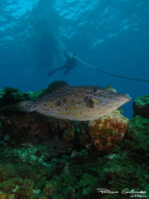
The Canary Islands offer year-round diving and has often been called the best diving in the Atlantic. While the waters are cooler than the southeast coast of the United States, they do not get very cold. The Canary Current keeps the water temperature around 73 °F (ca. 23 °C) in summer and around 64 °F (ca. 18 °C) in winter. Most divers find that a 5 mm wet suit will do them quite well in the summer and a 7 mm wet suit will do in the winter months. The Canary current and the distance from a major land mass helps keep the underwater visibility generally over 100 feet (ca. 30 meters)
The Canary Islands are near the continental shelf of Africa. Cold water from the deep brings nutrients from the depths to help nourish the reefs. These deep waters also bring large game fish and pelagic species. Dolphins, whales, and rays are found year-round. The eastern side of the islands may have more difficult conditions due to storms.
There are over 100 dive sites around the different islands. They represent a mix of boat diving and shore dives. There is a variety of types of diving:
- Underwater Landscapes: The islands are volcanic in nature resulting in awesome formations under the waves. Lava tubes, caves and swim through are common. In 2011, there was an eruption of an underwater volcano La Restinga Marine Reserve on the island of El Hierro.
- Marine Life: The marine life is intense. The biodiversity is amazing with temperate and semi-tropical species found together.
- Wreck diving: There are dozens of wrecks from many eras waiting for divers.
- Night dives: Night diving is very popular with a number of outstanding dive sites available.
The Promotur Turismo de Canarias has an excellent overview of the different dive sites of the Canary Islands. They also have a great app available from that page about the dive sites as well. While it seems that the dive site descriptions are only in Spanish, the site information is clear so that you are not hindered for not understanding the language.
Once you open the app, you can select the island you are interested in. A map appears showing the location of the major dive sites. Selecting a location brings up the information for the site. Most sites have a detail dive site map. It shows the different features of the dive site, it marked with depths and highlights of the site. A group of icons will tell you the experience level you should have to dive the site, currents, whether it is a boat site or shore site, any special equipment you might need. Additional information includes whether the site is good for snorkeling and discover diving, the type of underwater landscape and whether it is recommended for night dives. You can click the weather icon, for up to date weather and marine conditions.
Being only a 4 to 6-hour flight from mainland Europe, it is a great destination for a short holiday.