Thursday, November 30, 2023
OceanScientists Can Now Model The Biodiversity Of The Sea Floor

Scientists Can Now Model The Biodiversity Of The Sea Floor

-

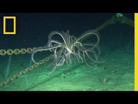
Oceanographers are now able to figure out how diverse the sea floor is without necessarily having to go down and look at it in its entirety.

The way it’s done is via satellite images of the surface of the ocean, according to a new National Geographic video. The satellites detect phytoplankton on the surface, and then scientists extrapolate that data to figure out where life exists at the bottom of the ocean.

Satellite imagery is especially useful in areas where it’s hard for humans to reach, like parts of the Antarctic/Southern Ocean. It also helps predict the effects of climate change.

To learn more, check out the NatGeo video below.

Plankton-Spotting Satellites Can Help Determine Ocean Health From Space | National Geographic

John Liang
John Lianghttps://www.deeperblue.com/
John Liang is the News Editor at DeeperBlue.com. He first got the diving bug while in High School in Cairo, Egypt, where he earned his PADI Open Water Diver certification in the Red Sea off the Sinai Peninsula. Since then, John has dived in a volcanic lake in Guatemala, among white-tipped sharks off the Pacific Coast of Costa Rica, and other places including a pool in Las Vegas helping to break the world record for the largest underwater press conference.

SEARCH

CONNECT WITH US

858,282FansLike
102,180FollowersFollow
0FollowersFollow
22,801FollowersFollow
0FollowersFollow
25,921FollowersFollow
2,080SubscribersSubscribe

RECENT ARTICLES